
| Official name | Republic of the Sudan |
| Name in local language | جمهورية السودان ; Jumhūriyyat as-Sūdān (ar) |
| Continent | Africa |
| Subcontinent | East Africa |
| Population (ranking: 32e) | 44,318,058 inhabitants (2021) |
| Population growth | 3.42 % / year |
| Area | 1,886,068 km² |
| Density | 23.50 inhabitants / km² |
| GDP (ranking: 111e) | 26.111 billions $USD (2020) |
| GDP/capita (ranking) | 596 $USD (2020) |
| GDP growth | -1.60 % / year (2020) |
| Life expectancy (ranking) | 65.10 years (2018) |
| Birth rate | 33.05 ‰ (2014) |
| Fertility rate | 4.35 children / woman (2014) |
| Death rate (ranking) | 7.76 ‰ (2014) |
| Infant mortality rate (ranking) | 47.60 ‰ (2015) |
| Literacy rate | 75.90 % (2015) |
| Official languages | Arabic, English |
| Currency | Sudanese pound (SDD) |
| HDI (ranking: 207e) | 0.510 / 1 (2019) |
| EPI (ranking) | 51.49 (2018) |
| Government | Federal presidential republic (de jure) under a Military junta (de facto) |
| Head of State | Chairman of the Sovereignty Council Abdel Fattah al-Burhan |
| National Day | 1st January (independence of 1956) |
| ISO Codes | SD, SDN |
| Demonym | Sudanese |
| Tourists (ranking) | 813,000 people (2017) |
Very strong demographic growth
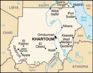
Sudan is a federal state in northeastern Africa. It is bordered to the north by Egypt, to the east by Eritrea and Ethiopia, to the south by South Sudan, from which it separated in 2011, and to the west by the Central African Republic, Chad and Libya. It is bathed in the east by the Red Sea.
See all related maps or articles
Urban areas (2019)
| Urban areas | Population |
|---|---|
| Khartoum | 8,524,021 inhabitants |
| Nyala | 738,154 inhabitants |
| Port Soudan | 499,279 inhabitants |
| Kassala | 455,669 inhabitants |
| al-Ubayyid | 420,929 inhabitants |
| Kusti | 415,593 inhabitants |
| Wad Madani | 356,978 inhabitants |
| al-Qadarif | 353,686 inhabitants |
| al-Fair | 275,515 inhabitants |
| ad-Duayn | 242,465 inhabitants |
See all urban areas
Administrative divisions
| States | Population | Area |
|---|---|---|
| Al Gedarif | 2,108,468 inhabitants | 75,263 km² |
| Al Gezira | 4,926,555 inhabitants | 27,549 km² |
| Blue Nile | 1,080,743 inhabitants | 45,844 km² |
| Central Darfur (recent creation) | 0 inhabitants | 0 km² |
| East Darfur (recent creation) | 0 inhabitants | 0 km² |
| Kassala | 2,438,808 inhabitants | 36,710 km² |
| Khartoum | 7,687,547 inhabitants | 22,142 km² |
| Nile River | 1,472,257 inhabitants | 122,123 km² |
| North Darfur | 2,296,068 inhabitants | 296,420 km² |
| North Kurdufan | 3,160,663 inhabitants | 185,302 km² |
| Northern | 913,533 inhabitants | 348,765 km² |
| Red Sea | 1,447,787 inhabitants | 218,887 km² |
| Sinnar | 1,847,458 inhabitants | 37,844 km² |
| South Darfur | 5,220,191 inhabitants | 127,300 km² |
| South Kurdufan | 2,047,294 inhabitants | 79,470 km² |
| West Darfur | 1,725,110 inhabitants | 79,460 km² |
| West Kurdufan (recent creation) | 0 inhabitants | 111,373 km² |
| White Nile | 2,410,260 inhabitants | 30,411 km² |