
| Official name | Netherlands Antilles |
| Name in local language | Nederlandse Antillen (nl) |
| Continent | Americas |
| Subcontinent | Caribbean |
| Population (ranking: 196e) | 230,304 inhabitants (2011) |
| Population growth | 0.69 % / year |
| Area | 960 km² |
| Density | 239.90 inhabitants / km² |
| GDP (ranking: 202e) | 2.450 billions $USD (2003) |
| GDP/capita (ranking) | 11,400 $USD (2003) |
| GDP growth | -3.90 % / year (2003) |
| Life expectancy (ranking) | 77.04 years (2011) |
| Birth rate | 13.91 ‰ (2011) |
| Fertility rate | 1.96 children / woman (2011) |
| Death rate (ranking) | 6.61 ‰ (2011) |
| Infant mortality rate (ranking) | 8.61 ‰ (2011) |
| Literacy rate | 96.30 % (2008) |
| Official languages | Dutch |
| Currency | Netherlands Antillean guilder (ANG) |
| HDI (ranking: n.c.) | 0.000 / 1 (2017) |
| EPI (ranking) | 0.00 (2018) |
| Government | Constitutional monarchy |
| Head of State | King Willem-Alexander |
| National Day | 1st November |
| ISO Codes | AN, ANT |
| Demonym | Dutch |
Dissolution of the federation
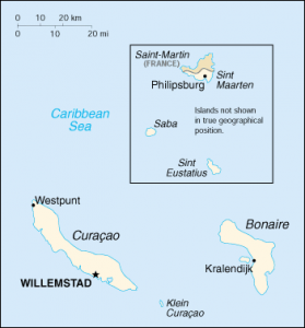
The Netherlands Antilles was an autonomous federation within the Kingdom of the Netherlands. They consisted mainly of the Curaçao Islands, Bonaire and the Dutch part of Saint Martin, plus some small secondary islands. Saint Martin is an island shared with France.
In October 2010, this federation of islands dissolved to evolve differently: Curaçao and Sint Maarten became autonomous states within the kingdom of the Netherlands, the islands of Bonaire, Saba and Saint Eustache were united to the Netherlands as special status municipalities.
Visit their respective sheets:
- Curaçao
- Sint Maarten
- Bonaire (to be created)
- Saba (to be created)
- Saint Eustache (to be created)
- Aruba
See all related maps or articles
Administrative divisions
| Islands | Population | Area |
|---|---|---|
| Curaçao | 146,836 inhabitants | 444 km² |
| Sint Maarten | 40,608 inhabitants | 34 km² |