
| Official name | Republic of Kenya |
| Name in local language | Jamhuri ya Kenya (sw) ; Republic of Kenya (en) |
| Continent | Africa |
| Subcontinent | East Africa |
| Population (ranking: 29e) | 50,773,109 inhabitants (2022) |
| Population growth | 2.20 % / year |
| Area | 580,876 km² |
| Density | 87.41 inhabitants / km² |
| GDP (ranking: 62e) | 110.347 billions $USD (2021) |
| GDP/capita (ranking) | 2,007 $USD (2021) |
| GDP growth | 7.50 % / year (2021) |
| Life expectancy (ranking) | 67.00 years (2020) |
| Birth rate | 27.90 ‰ (2019) |
| Fertility rate | 3.40 children / woman (2019) |
| Death rate (ranking) | 10.50 ‰ (2019) |
| Infant mortality rate (ranking) | 35.50 ‰ (2019) |
| Literacy rate | 77.97 % (2015) |
| Official languages | English, Swahili |
| Currency | Kenyan shilling (KES) |
| HDI (ranking: 186e) | 0.575 / 1 (2021) |
| EPI (ranking) | 47.25 (2018) |
| Government | Unitary presidential constitutional republic |
| Head of State | President William Ruto |
| National Day | 12 December (independence in 1963) |
| ISO Codes | KE, KEN |
| Demonym | Kenyan |
| Tourists (ranking) | 1,364,000 people (2017) |
Poverty remains high in the country, despite good economic health
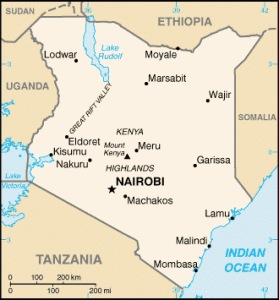
Kenya is a country in East Africa, bordered by South Sudan and Ethiopia to the north, Somalia to the east, Uganda to the west and Tanzania to the southwest. It is bathed by the Indian Ocean to the southeast.
Half of the country’s inhabitants live below the poverty line, despite good economic health that has lasted for a decade. The country is equipped with infrastructure, including roads and railway lines, but this economic boom does not benefit everyone, far from it.
See all related maps or articles
Urban areas (2022)
| Urban areas | Population |
|---|---|
| Nairobi | 7,490,979 inhabitants |
| Mombasa | 1,535,899 inhabitants |
| Nakuru | 610,637 inhabitants |
| Kisumu | 567,963 inhabitants |
| Eldoret | 507,748 inhabitants |
| Mandera | 460,708 inhabitants |
| Naivasha | 355,383 inhabitants |
| Malindi | 333,226 inhabitants |
| Njoro | 238,773 inhabitants |
| Maua | 221,412 inhabitants |
| Karuri | 207,396 inhabitants |
| Kitale | 203,821 inhabitants |
| Kakamega | 188,212 inhabitants |
| Dadaab | 185,252 inhabitants |
| Gilgil | 185,209 inhabitants |
| Bungoma | 177,748 inhabitants |
| Bomet | 175,215 inhabitants |
| Kericho | 170,625 inhabitants |
| Machakos | 170,606 inhabitants |
| Kisii | 166,906 inhabitants |
| Garissa | 163,914 inhabitants |
| Kajiado | 161,862 inhabitants |
| Molo | 156,732 inhabitants |
| Busia | 142,408 inhabitants |
| Nyeri | 140,338 inhabitants |
See all urban areas
Administrative divisions
| Counties | Population | Area |
|---|---|---|
| Baringo | 666,763 inhabitants | 10,976 km² |
| Bomet | 875,689 inhabitants | 2,531 km² |
| Bungoma | 1,670,570 inhabitants | 3,024 km² |
| Busia | 893,681 inhabitants | 1,696 km² |
| Elgeyo-Marakwet | 454,480 inhabitants | 3,032 km² |
| Embu | 608,599 inhabitants | 2,821 km² |
| Garissa | 841,353 inhabitants | 44,736 km² |
| Homa Bay | 1,131,950 inhabitants | 3,153 km² |
| Isiolo | 268,002 inhabitants | 25,351 km² |
| Kakamega | 1,867,579 inhabitants | 3,020 km² |
| Kericho | 901,777 inhabitants | 2,436 km² |
| Kiambu | 2,417,735 inhabitants | 2,539 km² |
| Kijiado | 1,117,840 inhabitants | 21,871 km² |
| Kilifi | 1,453,787 inhabitants | 12,540 km² |
| Kirinyaga | 610,411 inhabitants | 1,478 km² |
| Kisii | 1,266,860 inhabitants | 1,323 km² |
| Kisumu | 1,155,574 inhabitants | 2,085 km² |
| Kitui | 1,136,187 inhabitants | 30,430 km² |
| Kwale | 866,820 inhabitants | 8,267 km² |
| Laikipia | 518,560 inhabitants | 9,532 km² |
| Lamu | 143,920 inhabitants | 6,253 km² |
| Machakos | 1,421,932 inhabitants | 6,043 km² |
| Makueni | 987,653 inhabitants | 8,170 km² |
| Mandera | 867,457 inhabitants | 25,940 km² |
| Marsabit | 459,785 inhabitants | 70,944 km² |