
| Official name | New Zealand |
| Name in local language | New Zealand (en) ; Aotearoa (mi) |
| Continent | Oceania |
| Subcontinent | Oceania |
| Population (ranking: 124e) | 5,136,118 inhabitants (2023) |
| Population growth | 0.24 % / year |
| Area | 268,107 km² |
| Density | 19.16 inhabitants / km² |
| GDP (ranking: 47e) | 249.886 billions $USD (2021) |
| GDP/capita (ranking) | 48,781 $USD (2021) |
| GDP growth | 3.70 % / year (2021) |
| Life expectancy (ranking) | 82.30 years (2020) |
| Birth rate | 11.48 ‰ (2021) |
| Fertility rate | 1.64 children / woman (2022) |
| Death rate (ranking) | 6.83 ‰ (2021) |
| Infant mortality rate (ranking) | 4.65 ‰ (2021) |
| Literacy rate | 100.00 % (2023) |
| Official languages | English, Māori, NZ Sign Language |
| Currency | New Zealand dollar ($ NZD) |
| HDI (ranking: 20e) | 0.937 / 1 (2021) |
| EPI (ranking) | 75.96 (2018) |
| Government | Unitary parliamentary constitutional monarchy |
| Head of State | King Charles III ; Gouvernor-General Cindy Kiro ; Prime Minister Christopher Luxon |
| National Day | 6 February (Waitangi Day) |
| ISO Codes | NZ, NZL |
| Demonym | New Zealander |
| Tourists (ranking) | 206,862 people (2021) |
A relative isolation
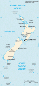
New Zealand is an Oceanian country located to the southwest of the Pacific Ocean, consisting of an archipelago of two main islands (the North Island and the South Island), and many other islands more small, including Stewart Island and Chatham Islands. The country is geographically rather isolated from the rest of the world, about 1600 km from Australia. This isolation has allowed the development of a rich and varied endemic flora and fauna.

Volcano of White Island. Source: Wildlife Archives
See all related maps or articles
Urban areas (2022)
| Urban areas | Population |
|---|---|
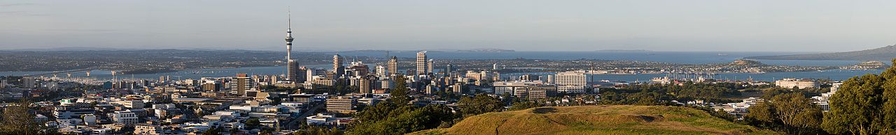
| Auckland | 1,695,200 inhabitants |
| Christchurch | 470,814 inhabitants |
| Wellington | 434,900 inhabitants |
| Hamilton | 241,200 inhabitants |
| Tauranga | 158,300 inhabitants |
| Napier-Hastings Maps: | 157,400 inhabitants |
| Dunedin | 130,400 inhabitants |
| Palmerston North | 92,004 inhabitants |
| New Plymouth | 87,700 inhabitants |
| Whangārei | 84,117 inhabitants |
| Nelson | 79,998 inhabitants |
| Rotorua | 76,800 inhabitants |
| Invercargill | 56,800 inhabitants |
See all urban areas
Administrative divisions
| Regions | Population | Area |
|---|---|---|
| Auckland | 1,695,200 inhabitants | 4,894 km² |
| Bay of Plenty | 347,700 inhabitants | 12,231 km² |
| Canterbury | 655,000 inhabitants | 44,638 km² |
| Gisborne | 52,100 inhabitants | 8,355 km² |
| Hawke's Bay | 182,700 inhabitants | 14,111 km² |
| Manawatu-Wanganui | 258,200 inhabitants | 22,206 km² |
| Marlborough | 51,900 inhabitants | 12,484 km² |
| Nelson | 54,500 inhabitants | 445 km² |
| North Island (Physical geography) | 3,922,000 inhabitants | 113,729 km² |
| Northland | 201,500 inhabitants | 13,789 km² |
| Otago | 246,000 inhabitants | 31,241 km² |
| South Island (Physical geography) | 1,201,300 inhabitants | 150,437 km² |
| Southland | 102,400 inhabitants | 32,079 km² |
| Taranaki | 127,300 inhabitants | 7,258 km² |
| Tasman | 58,700 inhabitants | 9,771 km² |
| Waikato | 513,800 inhabitants | 24,025 km² |
| Wellington | 543,500 inhabitants | 8,140 km² |
| West Coast | 32,700 inhabitants | 23,276 km² |