
| Official name | Republic of Ghana |
| Name in local language | Ghana |
| Continent | Africa |
| Subcontinent | Sub-Saharan Africa |
| Population (ranking: 49e) | 30,280,811 inhabitants (2019) |
| Population growth | 2.21 % / year |
| Area | 238,553 km² |
| Density | 126.94 inhabitants / km² |
| GDP (ranking: 75e) | 65.556 billions $USD (2018) |
| GDP/capita (ranking) | 2,202 $USD (2018) |
| GDP growth | 6.30 % / year (2018) |
| Life expectancy (ranking) | 63.80 years (2018) |
| Birth rate | 30.80 ‰ (2016) |
| Fertility rate | 4.03 children / woman (2016) |
| Death rate (ranking) | 7.10 ‰ (2016) |
| Infant mortality rate (ranking) | 36.30 ‰ (2016) |
| Literacy rate | 76.57 % (2015) |
| Official languages | English |
| Currency | Ghana cedi (₵ GHS) |
| HDI (ranking: 180e) | 0.596 / 1 (2018) |
| EPI (ranking) | 49.66 (2018) |
| Government | Unitary presidential constitutional republic |
| Head of State | President Nana Addo Dankwa Akufo-Addo |
| National Day | 6 March (independence in 1957) ; 1st July (republic) |
| ISO Codes | GH, GHA |
| Demonym | Ghanaian |
| Tourists (ranking) | 897,000 people (2015) |
A very strong development thanks to natural resources
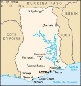
Ghana is a West African country located on the shores of the Gulf of Guinea. The neighboring countries of Ghana are Ivory Coast (Côte d’Ivoire) to the west, Burkina Faso to the north and Togo to the east.
The development of a country necessarily involves a stable and democratic political apparatus. Ghana, a very poor country, is now well established in the democratic system, and it is currently developing thanks to oil, as in the whole sub-region.
See all related maps or articles
Urban areas (2019)
| Urban areas | Population |
|---|---|
| Accra | 5,390,455 inhabitants |
| Kumasi | 2,477,604 inhabitants |
| Cape Coast | 1,256,805 inhabitants |
| Sekondi | 726,905 inhabitants |
| Tamale | 562,919 inhabitants |
| New Juaben | 227,573 inhabitants |
| Ho | 218,948 inhabitants |
| Bawku | 217,791 inhabitants |
| East Akim | 208,091 inhabitants |
| Hohoe | 205,870 inhabitants |
| Obuasi | 203,554 inhabitants |
| Yendi | 199,592 inhabitants |
| Mfantsiman | 196,563 inhabitants |
| Techiman | 182,810 inhabitants |
| Keta | 182,409 inhabitants |
| Birim | 178,830 inhabitants |
| Ejisu Juaben | 174,482 inhabitants |
| Assin North | 161,341 inhabitants |
| Sunyani | 151,378 inhabitants |
| Dormaa | 139,955 inhabitants |
| West Akim | 133,301 inhabitants |
| Asunafo North | 124,685 inhabitants |
See all urban areas
Administrative divisions
| Regions | Population | Area |
|---|---|---|
| Ashanti | 5,792,187 inhabitants | 24,389 km² |
| Brong Ahafo | 2,850,607 inhabitants | 39,557 km² |
| Central | 2,563,228 inhabitants | 9,826 km² |
| Eastern | 3,244,834 inhabitants | 19,323 km² |
| Greater Accra | 4,943,075 inhabitants | 3,245 km² |
| Northern | 3,062,883 inhabitants | 70,384 km² |
| Upper East | 1,273,677 inhabitants | 8,842 km² |
| Upper West | 849,123 inhabitants | 18,476 km² |
| Volta | 2,607,996 inhabitants | 20,570 km² |
| Western | 3,093,201 inhabitants | 23,921 km² |