
| Official name | Republic of Cyprus |
| Name in local language | Κυπριακή Δημοκρατία (el) ; Kıbrıs Cumhuriyeti (tr) |
| Continent | Europe |
| Subcontinent | European Union |
| Population (ranking: 164e) | 1,219,051 inhabitants (2018) |
| Population growth | 1.65 % / year |
| Area | 9,251 km² |
| Density | 131.78 inhabitants / km² |
| GDP (ranking: 114e) | 24.470 billions $USD (2018) |
| GDP/capita (ranking) | 28,159 $USD (2018) |
| GDP growth | 3.90 % / year (2018) |
| Life expectancy (ranking) | 80.80 years (2018) |
| Birth rate | 10.70 ‰ (2017) |
| Fertility rate | 1.32 children / woman (2015) |
| Death rate (ranking) | 6.90 ‰ (2015) |
| Infant mortality rate (ranking) | 1.30 ‰ (2017) |
| Literacy rate | 99.86 % (2015) |
| Official languages | Greek, Turkish |
| Currency | Euro (€ EUR) |
| HDI (ranking: 47e) | 0.873 / 1 (2018) |
| EPI (ranking) | 72.60 (2018) |
| Government | Unitary presidential constitutional republic |
| Head of State | President Nicos Anastasiades |
| National Day | 1st October (independence of 1960) |
| ISO Codes | CY, CYP |
| Demonym | Cypriot |
| Tourists (ranking) | 3,930,000 people (2018) |
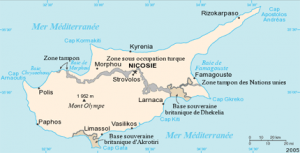
A country cut in half
Cyprus is an island state located in the eastern Mediterranean Sea, in the Levantine Basin, south of Turkey and east of Greece. Although Cyprus is geographically closer to the West Asia region, the country is culturally and politically linked to Europe and is a member of the European Union.

The Cypriot Republic is a member of the United Nations (1960), the British Commonwealth, the European Union (2004), the WTO, the OSCE, the Non-Aligned Movement, the International Labor Organization and the Francophonie. Cyprus joined the euro area on 1 January 2008.
Since 1974, the northern part of the island, located beyond the UN-controlled Green Line, is under Turkish military occupation, and in 1983, the territory proclaimed itself “Turkish Republic of Northern Cyprus” without that it is recognized by the international community, with the exception of Turkey.
Of the total population estimated at 1,219,051 in 2018, 864,200 people are counted in the part controlled by the Cypriot government (south). The remainder, 354,851 inhabitants, is partly Turkish occupied in the north of the island.
The Turkish military occupation of the north of the island is one of the major blocking factors of Turkey’s entry into the European Union.
As far as possible, we have compiled the figures of the two statistical institutes (Cyprus and Northern Cyprus): population, GDP, tourists, among others.
See all related maps or articles
Urban areas (2017)
| Urban areas | Population |
|---|---|
| Nicosie | 351,164 inhabitants |
| Limassol | 265,274 inhabitants |
| Larnaca | 89,795 inhabitants |
| Kyrenia (Girne) | 64,884 inhabitants |
| Paphos | 64,442 inhabitants |
| Famagouste | 50,465 inhabitants |
See all urban areas
Administrative divisions
| Districts | Population | Area |
|---|---|---|
| Famagouste | 46,900 inhabitants | 244 km² |
| Famagouste (Gazimağusa) (Chypre du Nord) | 69,741 inhabitants | 997 km² |
| Kyrenia (Girne) (Chypre du Nord) | 69,163 inhabitants | 690 km² |
| Larnaca | 144,200 inhabitants | 1,041 km² |
| Limassol | 237,000 inhabitants | 1,393 km² |
| Morphou (Güzelyurt) (Chypre du Nord) | 30,037 inhabitants | 381 km² |
| Nicosie | 330,000 inhabitants | 1,924 km² |
| Nicosie (Lefkoşa) (Chypre du Nord) | 94,824 inhabitants | 502 km² |
| Paphos | 90,200 inhabitants | 1,390 km² |
| Trikomo (İskele) (Chypre du Nord) | 22,492 inhabitants | 774 km² |