Secondary Menu
Home
World – Country Profiles
Africa
Americas
Antarctica
Asia
Europe
Oceania
Themes
Demography
Environment
Globalization
Health
Humanitarian
Human Rights
Institutions
Miscellaneous
Poverty
Society
Rankings – All Statistics
Birth Rate
Countries and Territories of the World (Population)
Environmental Performance Index (EPI)
GDP
GDP/Capita
Human Development Index (HDI)
Infant Mortality
Life Expectancy
Mortality
Most Spoken Languages in the World
Tourism
World’s Largest Cities
ImagesSat
Maps
Historical Maps
Lights of the World HD
North Magnetic Pole
Political Map of the World
Time Zone
Tools
List of ISO Codes
Metric System – Imperial System
Periodic Table of Elements
GeoFolios
GeoFolio – Humanitarian
GeoFolio – Nature
GeoFolio – Urbanization
FR
France
Map list
Lyon – satellite
Source: Google Maps
See the map
Marseille – routière
Source: Google Maps
See the map
Marseille – satellite
Source: Google Maps
See the map
Nantes – routière
Source: Google Maps
See the map
Nantes – satellite
Source: Google Maps
See the map
NATO – Member Countries
Source: Wikipedia
See the map
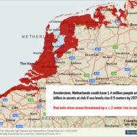
Netherlands : sea level
Source: University of Arizona / Business Insider
See the map
Nice – routière
Source: Google Maps
See the map
Nice – satellite
Source: Google Maps
See the map
Paris – routière
Source: Google Maps
See the map
Paris – satellite
Source: Google Maps
See the map
Paris – urbanization (timelapse 1984-2012)
Source: Landsat
See the map
Rennes – routière
Source: Google Maps
See the map
Rennes – satellite
Source: Google Maps
See the map
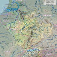
Rhine – watershed
Source: Wikipedia
See the map
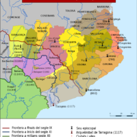
Spain-France – Catalonia: Catalan counties (8th-12th centuries)
Source: Wikipedia
See the map
Strasbourg – routière
Source: Google Maps
See the map
Strasbourg – satellite
Source: Google Maps
See the map
Toulouse – routière
Source: Google Maps
See the map
Toulouse – satellite
Source: Google Maps
See the map
« First
‹ Previous
1
6
7
8
9
10
Next ›
Last »