
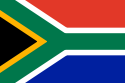
| Official name | Republic of South Africa |
| Name in local language | Republiek van Suid-Afrika (af) ; iRiphabhuliki yaseNingizimu Afrika (zu) |
| Continent | Africa |
| Subcontinent | Southern Africa |
| Population (ranking: 25e) | 57,725,606 inhabitants (2018) |
| Population growth | 2.13 % / year |
| Area | 1,219,912 km² |
| Density | 47.32 inhabitants / km² |
| GDP (ranking: 35e) | 366.298 billions $USD (2018) |
| GDP/capita (ranking) | 6,340 $USD (2018) |
| GDP growth | 0.60 % / year (2018) |
| Life expectancy (ranking) | 63.90 years (2018) |
| Birth rate | 21.30 ‰ (2017) |
| Fertility rate | 2.41 children / woman (2017) |
| Death rate (ranking) | 9.00 ‰ (2017) |
| Infant mortality rate (ranking) | 32.80 ‰ (2017) |
| Literacy rate | 99.03 % (2015) |
| Official languages | Zulu, Afrikaans, English (11 languages) |
| Currency | Rand (ZAR) |
| HDI (ranking: 149e) | 0.705 / 1 (2018) |
| EPI (ranking) | 44.73 (2018) |
| Government | Unitary parliamentary constitutional republic |
| Head of State | President Cyril Ramaphosa |
| National Day | 27 April (first multiracial elections in 1994) |
| ISO Codes | ZA, ZAF |
| Demonym | South African |
| Tourists (ranking) | 10,285,000 people (2017) |

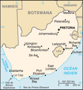
South Africa is a country located on the southern tip of the African continent. It is bordered to the north with Namibia, Botswana and Zimbabwe, and to the north-east with Mozambique and Swaziland. Lesotho is a landlocked state in South Africa.


See all related maps or articles
Urban areas (2016)
| Urban areas | Population |
|---|---|
|
Gauteng (Johannesburg-Pretoria)
Maps:
|
14,717,040 inhabitants |
| Johannesburg | 4,949,347 inhabitants |
| Le Cap (capitale législative) | 4,004,793 inhabitants |
| eThekwini (Durban) | 3,661,911 inhabitants |
|
Ekurhuleni
Maps:
|
3,379,104 inhabitants |
| Tshwane (Prétoria - capitale administrative) | 3,275,152 inhabitants |
| Nelson Mandela Bay (Port Elizabeth) | 1,263,051 inhabitants |
| Buffalo City (East London) | 810,528 inhabitants |
| Mangaung (Bloemfontein - capitale judiciaire) | 759,693 inhabitants |
|
Emfuleni (Vereeniging)
Maps:
|
733,445 inhabitants |
| Polokwane (Pietersburg) | 702,190 inhabitants |
| Msunduzi (Pietermaritzburg) | 679,766 inhabitants |
| Thulamela | 657,982 inhabitants |
| Rustenburg | 626,522 inhabitants |
| Mbombela (Nelspruit) | 622,158 inhabitants |
| Bushbuckridge | 548,760 inhabitants |
| Makhado | 542,416 inhabitants |
| Madibeng | 537,516 inhabitants |
| King Sabata Dalindyebo | 490,207 inhabitants |
| Emalahleni (Witbank) | 455,228 inhabitants |
| Matjhabeng (Welkom) | 428,843 inhabitants |
| Matlosana | 417,282 inhabitants |
| Tzaneen | 416,488 inhabitants |
| Nkomazi | 410,907 inhabitants |
| Tubatse (Burgersfort) | 393,713 inhabitants |
See all urban areas
Administrative divisions
| Provinces | Population | Area |
|---|---|---|
| Eastern Cape | 6,522,734 inhabitants | 169,580 km² |
| Free State | 2,954,348 inhabitants | 129,480 km² |
| Gauteng | 14,717,040 inhabitants | 17,010 km² |
| KwaZulu-Natal | 11,384,722 inhabitants | 92,100 km² |
| Limpopo | 5,797,275 inhabitants | 123,900 km² |
| Mpumalanga | 4,523,874 inhabitants | 79,490 km² |
| North West | 3,978,955 inhabitants | 116,320 km² |
| Northern Cape | 1,225,555 inhabitants | 361,830 km² |
| Western Cape | 6,621,103 inhabitants | 129,370 km² |