Official name
Democratic Republic of Timor-Leste
Name in local language
República Democrática de Timor-Leste (pt) ; Repúblika Demokrátika Timór-Leste (tet)
Continent
Asia
Subcontinent
Southeast Asia
Population (ranking: 163e )
1,261,407 inhabitants (2018)
Population growth
1.60 % / year
Area
14,954 km²
Density
84.35 inhabitants / km²
GDP (ranking: 188e )2.581 billions $USD (2018)
GDP/capita (ranking )
2,036 $USD (2018)
GDP growth
2.80 % / year (2018)
Life expectancy (ranking )
69.30 years (2018)
Birth rate
36.02 ‰ (2015)
Fertility rate
4.90 children / woman (2016)
Death rate (ranking )
9.14 ‰ (2015)
Infant mortality rate (ranking )
36.30 ‰ (2016)
Literacy rate
82.24 % (2015)
Official languages
Tetum, Portuguese
Currency
United States Dollar ($ USD)
HDI (ranking: 170e )0.626 / 1 (2018)
EPI (ranking )49.54 (2018)
Government
Unitary semi-presidential constitutional republic
Head of State
President Francisco Guterres
National Day
28 November (independence declared in 1975)
ISO Codes TL, TLS
Demonym
East Timorese
Tourists (ranking )
74,000 people (2017)
A difficult independence
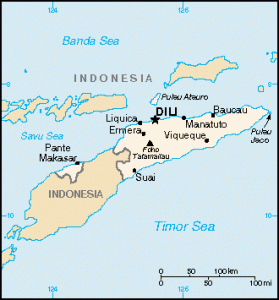
East Timor (or Timor-Leste ) is a country in Southeast Asia. It consists of the eastern half of the island of Timor, and the Oecusse, an enclave located in the western part of the island of Timor, surrounded by West Timor under Indonesian sovereignty, as well as the islands of Atauro and Jaco. The country is surrounded by Indonesia , just north of Australia . The capital of East Timor is Dili.
Dili, capitale of East Timor. Photo: GG Travelblog Beach in East Timor Urban areas (2017)
Urban areas
Population
Dili
277,279 inhabitants
Administrative divisions
Districts/Municipalities
Population
Area
Aileu
48,837 inhabitants
676 km²
Ainaro
63,136 inhabitants
870 km²
Baucau
123,203 inhabitants
1,508 km²
Bobonaro
97,762 inhabitants
1,381 km²
Cova Lima
65,301 inhabitants
1,207 km²
Dili
277,279 inhabitants
368 km²
Ermera
125,702 inhabitants
771 km²
Lautém
65,240 inhabitants
1,813 km²
Liquiçá
71,927 inhabitants
551 km²
Manatuto
46,619 inhabitants
1,786 km²
Manufahi
53,691 inhabitants
1,327 km²
Oecusse
68,913 inhabitants
817 km²
Viqueque
76,033 inhabitants
1,880 km²
See also