Official name
Saint Vincent and the Grenadines
Name in local language
Saint Vincent and the Grenadines (en)
Continent
Americas
Subcontinent
Caribbean
Population (ranking: 207e )
110,784 inhabitants (2021)
Population growth
0.08 % / year
Area
384 km²
Density
288.50 inhabitants / km²
GDP (ranking: 217e )0.825 billions $USD (2019)
GDP/capita (ranking )
7,458 $USD (2019)
GDP growth
0.50 % / year (2019)
Life expectancy (ranking )
73.00 years (2018)
Birth rate
13.90 ‰ (2017)
Fertility rate
1.90 children / woman (2017)
Death rate (ranking )
8.00 ‰ (2016)
Infant mortality rate (ranking )
13.30 ‰ (2016)
Literacy rate
99.00 % (2017)
Official languages
English, Creole (French spoken)
Currency
East Caribbean dollar ($ XCD)
HDI (ranking: 126e )0.738 / 1 (2019)
EPI (ranking )66.48 (2018)
Government
Unitary parliamentary constitutional monarchy
Head of State
Queen Elizabeth II ; Governor-General Susan Dougan
National Day
27 October (independence of 1979)
ISO Codes VC, VCT
Demonym
Vincentian
Tourists (ranking )
80,000 people (2018)
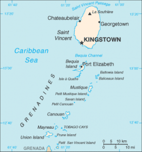
St. Vincent and the Grenadines is a Caribbean-based state of the Lesser Antilles, located west of Barbados , between Saint Lucia and Grenada . It consists of the main island of St. Vincent and a string of smaller islands, the Grenadines, located south of the archipelago. The main ones are Bequia, Baliceaux, Mosquito, Canouan, Mayreau, Tobago Cays, Union and Petit-Saint-Vincent. This last island marking the limit with Grenada.
Saint Vincent and the Grenadines Urban areas (2017)
Urban areas
Population
Kingstown
71,962 inhabitants
Administrative divisions
Parishes
Population
Area
Charlotte
30,901 inhabitants
148 km²
Grenadines
10,250 inhabitants
42 km²
Saint-Andrew
20,183 inhabitants
28 km²
Saint-David
5,765 inhabitants
79 km²
Saint-George
37,174 inhabitants
51 km²
Saint-Patrick
5,893 inhabitants
36 km²
See also