Secondary Menu
Home
World – Country Profiles
Africa
Americas
Antarctica
Asia
Europe
Oceania
Themes
Demography
Environment
Globalization
Health
Humanitarian
Human Rights
Institutions
Miscellaneous
Poverty
Society
Rankings – All Statistics
Birth Rate
Countries and Territories of the World (Population)
Environmental Performance Index (EPI)
GDP
GDP/Capita
Human Development Index (HDI)
Infant Mortality
Life Expectancy
Mortality
Most Spoken Languages in the World
Tourism
World’s Largest Cities
ImagesSat
Maps
Historical Maps
Lights of the World HD
North Magnetic Pole
Political Map of the World
Time Zone
Tools
List of ISO Codes
Metric System – Imperial System
Periodic Table of Elements
GeoFolios
GeoFolio – Humanitarian
GeoFolio – Nature
GeoFolio – Urbanization
FR
Australia
Map list
Australie – routière
Source: Google Maps
See the map
Australie – satellite
Source: Google Maps
See the map
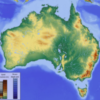
Australie – topographique
Source: Wikipédia
See the map
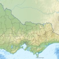
Australie – Victoria : topographique
Source: Wikipédia
See the map
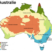
Australie – zones climatiques
Source: Wikipédia
See the map
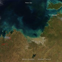
Australie : feux de forêt (juin 2010)
Source: Nasa Earth Observatory
See the map
Ayers Rock (Uluru) – satellite
Source: Google Maps
See the map
Brisbane – routière
Source: Google Maps
See the map
Brisbane – satellite
Source: Google Maps
See the map
Canberra – routière
Source: Google Maps
See the map
Canberra – satellite
Source: Google Maps
See the map
Darwin – routière
Source: Google Maps
See the map
Darwin – satellite
Source: Google Maps
See the map
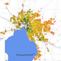
Melbourne – change in population density (1986-2011)
Source: Wikipedia
See the map
Melbourne – routière
Source: Google Maps
See the map
Melbourne – satellite
Source: Google Maps
See the map
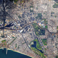
Melbourne – satellite
Source: NASA
See the map
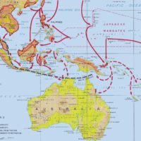
Pacific War: Japanese Advances (1942)
Source: Wikipedia
See the map
Perth – routière
Source: Google Maps
See the map
Perth – satellite
Source: Google Maps
See the map
« First
‹ Previous
1
2
3
Next ›
Last »