Trinidad and Tobago March 11, 2020 Americas , Antilles , archipelago , Atlantic , Atlantic Ocean , British colony , British Commonwealth , cacao , Caraïbe orientale , Caribbean , Caribbean Sea , Caribbean tectonic plate , Caricom , Cerro del Aripo , colony , Commonwealth , créole , english , English language , fiscal paradise , FPEG , French colony , gas , Gas Exporting Countries Forum , golfe de Paria , hydrocarbons , islands , Latin America , Leeward Islands , Lesser Antilles , oil , Organisation des États de la Caraïbe orientale , Port of Spain , Port-d'Espagne , San Fernando , Scarborough , Tobago , Trinidad , Trinidad and Tobago , Trinité Official name Republic of Trinidad and Tobago Name in local language Republic of Trinidad and Tobago (en) Continent Americas Subcontinent Caribbean Population (ranking: 160e ) 1,359,193 inhabitants (2018) Population growth 0.00 % / year Area 5,155 km² Density 263.66 inhabitants / km² GDP (ranking: 116e )23.410 billions $USD (2018) GDP/capita (ranking ) 16,844 $USD (2018) GDP growth 0.70 % / year (2018) Life expectancy (ranking ) 73.40 years (2018) Birth rate 12.83 ‰ (2016) Fertility rate 1.71 children / woman (2016) Death rate (ranking ) 8.23 ‰ (2016) Infant mortality rate (ranking ) 23.00 ‰ (2016) Literacy rate 99.00 % (2015) Official languages English Currency Trinidad and Tobago dollar ($ TTD) HDI (ranking: 90e )0.799 / 1 (2018) EPI (ranking )67.36 (2018) Government Unitary parliamentary constitutional republic Head of State President Paula-Mae Weekes National Day 31 August (independence of 1962) ISO Codes TT, TTO Demonym Trinidadians and Tobagonians Tourists (ranking ) 395,000 people (2017)
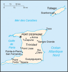
Trinidad and Tobago is a Caribbean island state located in the Caribbean Sea, off Venezuela and south of Grenada , and a member of the British Commonwealth. The archipelago is made up of two islands 32 kilometers apart: Trinidad and Tobago.
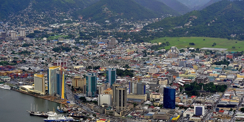
Port of Spain, capitale of Trinidad and Tobago. Photo: Central Statistical Office of Trinidad and Tobago Urban areas (2017) Urban areas Population Port-d'Espagne 829,097 inhabitants San Fernando 353,386 inhabitants Scarborough 49,882 inhabitants
Administrative divisions Regions, Borough, Cities Population Area Arima (Borough) 33,606 inhabitants 11 km² Chaguanas (Borough) 83,516 inhabitants 60 km² Couva-Tabaquite-Talparo 178,410 inhabitants 720 km² Diego Martin 102,957 inhabitants 128 km² Penal-Debe 89,392 inhabitants 247 km² Point Fortin (Borough) 20,235 inhabitants 24 km² Port-d'Espagne (Ville) 37,074 inhabitants 13 km² Princes Town 102,375 inhabitants 621 km² Rio Claro-Mayaro 35,650 inhabitants 853 km² San Fernando (Ville) 48,838 inhabitants 19 km² San Juan-Laventille 157,258 inhabitants 220 km² Sangre Grande 75,766 inhabitants 899 km² Siparia 86,949 inhabitants 510 km² Tobago 60,874 inhabitants 303 km² Tunapuna-Piarco 215,119 inhabitants 527 km²
See also