
| Official name | Republic of Namibia |
| Name in local language | Republic of Namibia (en) |
| Continent | Africa |
| Subcontinent | Southern Africa |
| Population (ranking: 147e) | 2,352,592 inhabitants (2018) |
| Population growth | 1.55 % / year |
| Area | 824,116 km² |
| Density | 2.85 inhabitants / km² |
| GDP (ranking: 132e) | 14.522 billions $USD (2018) |
| GDP/capita (ranking) | 5,931 $USD (2018) |
| GDP growth | -0.10 % / year (2018) |
| Life expectancy (ranking) | 63.40 years (2018) |
| Birth rate | 29.73 ‰ (2014) |
| Fertility rate | 3.52 children / woman (2014) |
| Death rate (ranking) | 7.10 ‰ (2014) |
| Infant mortality rate (ranking) | 32.80 ‰ (2015) |
| Literacy rate | 94.88 % (2015) |
| Official languages | English |
| Currency | Namibian dollar ($ NAD) |
| HDI (ranking: 168e) | 0.645 / 1 (2018) |
| EPI (ranking) | 58.46 (2018) |
| Government | Unitary dominant-party semi-presidential republic |
| Head of State | President Hage Geingob |
| National Day | 21 March (independence in 1990) |
| ISO Codes | NA, NAM |
| Demonym | Namibian |
| Tourists (ranking) | 1,469,000 people (2016) |
A country still too dependent on the outside
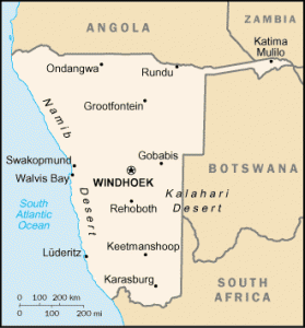
Namibia is a sparsely populated country in southern Africa bordered by the Atlantic Ocean to the west, South Africa to the south, Botswana to the east, Angola to the north and Zambia to the northeast. Although it has no border with Zimbabwe, only 200 meters separate the two countries at the crossroads of Kazungula. It is largely desert, with one of the lowest population densities in the world.

See all related maps or articles
Urban areas (2016)
| Urban areas | Population |
|---|---|
| Windhoek | 404,958 inhabitants |
| Rundu | 86,139 inhabitants |
| Walvis Bay | 75,260 inhabitants |
| Swakopmund | 64,373 inhabitants |
| Lüderitz | 12,926 inhabitants |
See all urban areas
Administrative divisions
| Regions | Population | Area |
|---|---|---|
| Caprivi | 90,596 inhabitants | 14,528 km² |
| Erongo | 150,809 inhabitants | 63,579 km² |
| Hardap | 79,507 inhabitants | 109,651 km² |
| Karas | 77,421 inhabitants | 161,215 km² |
| Kavango | 223,352 inhabitants | 48,463 km² |
| Khomas | 342,141 inhabitants | 37,007 km² |
| Kunene | 86,856 inhabitants | 115,293 km² |
| Ohangwena | 245,446 inhabitants | 10,703 km² |
| Omaheke | 71,233 inhabitants | 84,612 km² |
| Omusati | 243,166 inhabitants | 26,573 km² |
| Oshana | 176,674 inhabitants | 8,653 km² |
| Oshikoto | 181,973 inhabitants | 38,653 km² |
| Otjozondjupa | 143,903 inhabitants | 105,185 km² |